

The Art of Education
Methodology and Didactics
GA 294
2 September 1919, Stuttgart
Translated by Steiner Online Library
Eleventh Lecture
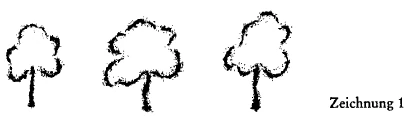
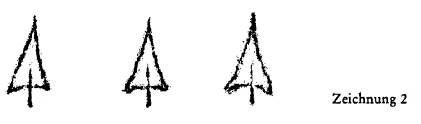
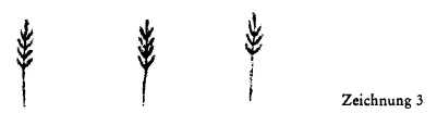
[ 1 ] I have told you that geography instruction can first be introduced during the second stage of elementary school. We can begin teaching geography once children are past the age of 9. We just need to structure it properly. In fact, in the elementary school curriculum of the future—and this applies even to middle school education—we must ensure that geography instruction encompasses much more than it does at present. Geography is currently given far too little attention; it is truly treated as a stepchild. The achievements of the other subjects should actually converge with geography in many ways, as if into a single whole. And although I have told you that mineralogy instruction does not begin until the third stage—around the age of 12—minerals can still be woven into geography to some extent in the earlier lower grades through descriptive and observational study. Children can absorb an extraordinary amount from geography between the ages of 9 and 12, provided we approach geography in the right way. The key here is that, especially in geography, we build upon what the child already knows in some way about the Earth’s surface and what happens on it. We begin by skillfully helping the child form a mental picture of the mountain and river features, as well as other aspects of the surrounding environment. We do this by actually working with the child to create a basic map of the immediate surroundings in which the child is growing up and which the child knows. We try to teach the child how to translate the experience of being inside a region into viewing it from an aerial perspective or through an aerial perspective—that is, the transformation of the initially familiar region into a map. We try to teach the child how the rivers flow through this area; that is, we actually draw the river and stream system of the surroundings onto the map, into which we gradually transform our perception of the surroundings. And we also mark the mountainous features on this map. It’s good to use colors here—drawing the rivers in blue and the mountains with brown chalk. But then we also mark on this map the other elements related to human life. We draw the various features of the landscape onto this map, drawing the child’s attention to them: “Look, a certain part of the area is planted with fruit trees,” and we draw the fruit trees (see Drawing 1). We point out to the child that there is also a coniferous forest there and mark the areas covered by coniferous forest as well (see Drawing 2). We point out to the child that part of the area is covered with grain crops and mark these areas as well (see Drawing 3).

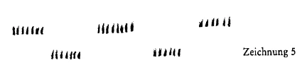
[ 2 ] Then we point out that there are meadows and mark them on the map (see Figure 4). This drawing shows the meadows that we can mow. We tell the child this. We also mark the meadows that we cannot mow but can still use to drive livestock onto so they can graze on the grass that remains short and sparse there (see Figure 5), and we tell the child that these are pasturelands. This is how we bring the map to life for the child. Through this map, the child gains a kind of overview of the economic foundations of the region. But then we also draw the child’s attention to the fact that there are all sorts of things inside the mountains: coal, ores, and so on. And we further point out to the child that the rivers are used to transport goods—things that are grown or manufactured in one place—to another. We explain to the child many aspects related to the economic structure of a region. After we have clarified the economic foundations—in rivers and mountains, in meadows, forests, and so on—as far as possible given the knowledge we can impart to the child, we mark the villages or towns located in the area we intend to cover first in their proper places on the map. And then we begin to point out to the child how the development of small villages in specific locations is connected to what is found in the mountains—what can be produced there—and how it relates to the courses of streams and rivers. In short, we try to use the map to evoke in the child a certain mental image of the economic interrelationships between the natural landscape and human living conditions; then we try to evoke in the child a certain mental image of the difference between rural and urban living conditions. To the extent that the child is already able to grasp this, we pursue it thoroughly. And finally, we also move on to what humans do through their economic activities to actively adapt to natural conditions. That is, we begin by drawing the child’s attention to the fact that humans create artificial waterways in the form of canals and build railroads. Then we point out to the child how railroads facilitate the transport of food, goods, and people themselves into daily life. Once we have worked for some time to help the child understand the economic connection between natural conditions and human living conditions, we can then use the concepts we have thus evoked in the child to extend the subject to the broader context of the Earth. If we have only done this first stage correctly, it will not be necessary for us to resort to excessive pedantry. The pedant will now say: It is only natural that we first study local geography in the narrowest sense and then expand the subject concentrically outward. — That is already pedantry. There is no need to proceed in that way. Rather, once a foundation has been laid for understanding the connection between nature and human beings, one can then calmly move on to something else. One then moves on to something else in such a way that one can also develop, as well and as intensively as possible, the economic connections between human beings and natural conditions. Take our region here, for example: after having developed the necessary concepts in familiar territories—by orienting the child to the local area and, so to speak, broadening their horizons—one moves on to telling the child: “There are the Alps.” — Let’s move on to the geography of the Alps. You have taught the child to draw maps. You can now expand this map-drawing by drawing a line for the child that marks where the Southern Alps border the Mediterranean Sea. As you sketch the northern part of Italy, the Adriatic Sea, and so on, you tell the child: “There are large rivers there”—and you also draw the river courses into this area. One can then move on to drawing for the child: the Rhône, the Rhine, the Inn, and the Danube with their tributaries. One can then draw in the individual segments of the Alpine range. And the child will be extraordinarily captivated when one explains how the individual segments of the Alpine range, for example, are separated from one another by the river courses. Feel free to draw red lines—which are now conceptual lines—along the blue lines of the rivers; for example, along the Rhône, from Lake Geneva to its source, and then move on to the Rhine and so on; then draw the line across the Arlberg and so on, then the line of the Drau, the Enns, and so on—in this way, using such red lines running from west to east to divide the Alps, so that you can say to the child: “Look, I’ve now drawn a red line along the river courses down below and a red line up above. What lies between these two red lines are different parts of the Alps than what lies above the red line and what lies below it.” - And now show the child—this is where the mineralogy lesson merges with the geography lesson; it emerges, for example, from a piece of Jurassic limestone—and say to him: “Look, the mountain ranges above the upper red line consist of this kind of limestone, and what lies below the red line also consists of this kind of limestone.” — And for what lies in between, show them a piece of granite or gneiss and say: “The mountains in the middle consist of this kind of rock, which is primary rock.” - And the child will already be tremendously interested in this Alpine massif, which you might even show him on a topographic map that includes a side view as well as an aerial view, if you vividly explain to him that the Alpine ranges are divided by river courses: the Limestone Alps. Mountain ranges with gneiss, mica schist, clay schist, and so on—and that the mountain massif, the entire mountain range stretching from south to north, simply curves and thus places these side by side: limestone mountains—primordial mountains—limestone mountains, separated by the river courses. You can incorporate many elements that go beyond pedantic visual instruction and greatly expand the child’s conceptual world.
[ 3 ] But then you move on—you have already laid the groundwork for this in nature class—to describe to the child what grows down in the valley, what grows higher up, and what grows at the very top, as well as what does not grow at the very, very top. You move on to vegetation in the vertical direction.
[ 4 ] And now you begin to draw the child’s attention to how people adapt to living in such a region, which is primarily defined by the mountain range. You begin to describe to him, in vivid detail, a small mountain village situated quite high up—which you sketch for him—and how the people there live. And you describe to them a village and roads located down in the valley. And then the towns that are situated where a river takes in a tributary. Then, within these broader contexts, you describe the relationship between the natural landscape and human economic life. You build up this human economic life, so to speak, from nature itself, by also drawing the child’s attention to where ores and coal are found, how these determine the settlements, and so on.
[ 5 ] Then draw him a region with few mountains, a flat region, and treat it in the same way. First, describe the natural conditions—the nature of the soil—and point out right away that different things thrive on poor soil than on rich soil. Point out the internal composition of the soil—this can be done using simple methods—on which potatoes grow; the composition of the soil on which wheat grows, on which rye grows, and so on. You have, of course, already taught the child the difference between wheat, rye, and oats. Do not hesitate to teach the child certain things that they initially grasp only in general terms—things they will understand more clearly only when they are revisited from a different perspective in later lessons. However, up until the age of 12, focus primarily on introducing the child to economic conditions. Make these clear to them. Focus more on internal geography than on providing a complete picture of the Earth at this stage. But it is still important to point out that the sea is very large. You have already begun to draw it near the Southern Alps, where you drew the Mediterranean Sea adjacent to them. Draw the sea as a blue area. Then draw the outer outlines of Spain and France for the child, show them how a large sea lies to the west, and gradually lead them to understand that America also exists. This mental image should be introduced before the age of 12.
[ 6 ] If you start out this way with a solid foundation, then around the age of 12 you can count on the child to show understanding when you proceed systematically, when you spend a short period of time ensuring that the child truly forms a picture of the Earth by teaching them the five continents, the oceans —albeit in a more concise way than you did before—and then describe the economic life of these different regions of the world. From the foundation you have laid, you should be able to draw out everything else. Once you have, as mentioned, summarized across the entire globe the knowledge of economic life you have instilled in the child, then proceed—precisely at the point when you may have already been teaching history for half a year in the manner we learned—to discuss with the children the spiritual conditions of the people who inhabit the various regions of the world. But do not fail to introduce this distinction only after you have made the child’s soul somewhat receptive to it through the initial history lessons. Then you can also discuss the geographical distribution of the character traits of the various peoples. But do not discuss the differences in character among the various peoples any earlier than this specific time, for it is then—building on the foundation I have described to you—that the child will be most receptive to this lesson. At that point, you can tell them about the differences between the Asian, European, and American peoples, as well as the differences between the Mediterranean peoples and the Nordic peoples of Europe. At that point, you can begin to gradually combine geography with history. You will be fulfilling a wonderful task that delights the child if you carry out what I have just described, preferably between the age of 12 and the end of elementary school—that is, up to around the age of 15. You can see that an extraordinary amount of effort should be invested in geography lessons so that they truly become a kind of synthesis of what is otherwise being taught. Just think of all the different elements that can converge in geography! Finally, it will even be possible to create a wonderful interplay between geography and history. Then, once you have incorporated various elements into your geography lessons in this way, you will also be able to draw many things from them in return. Of course, this will place some demands on your imagination and your inventiveness. When you tell the child that this or that is done here or there—for example, that the Japanese make their paintings in such-and-such a way—then try to encourage the child to do something similar in their own simple, primitive way. Do not neglect, right from the start, to teach the child the connection between agriculture and human life, and to give the child a clear mental image of the plow, the harrow, and so on, in connection with geographical concepts. And try to have the child imitate some of these things, even if only as a small plaything or work of art. This will develop the child’s dexterity and prepare them to engage with life in the right way later on. And if one could even make small plows and let the children till the soil in the school garden, if one could let them mow with small sickles or cut with small scythes, one would establish a meaningful connection to life. For more important than manual dexterity is the spiritual connection between the child’s life and life in the world. For it is indeed true: a child who has cut grass with a sickle, mowed grass with a scythe, or plowed furrows with a small plow becomes a different person than a child who has not done so. The child’s inner life simply becomes something else as a result. Abstract manual arts instruction cannot really replace this. And activities like arranging sticks and weaving paper should be avoided at all costs, because they tend to discourage placing the child within life rather than fostering this integration into life. It is much better to encourage the child to do things that actually happen in life than to invent things that do not happen in life. By structuring the child’s geography lessons as I have described, we familiarize the child in the most natural way possible with the fact that human life is shaped in various ways from different perspectives. And in doing so, we take into account what the child is always able to understand well. In geography lessons, we first describe economic and external conditions to the child from ages 9 to 12. We then guide them further toward understanding the cultural and intellectual conditions of the various peoples. And there, while saving everything else for a later time, we gently draw their attention to the legal relationships prevailing among the peoples. But we allow only the very first, most primitive concepts to shine through the economic and intellectual life. For the child does not yet have a full understanding of legal relationships. And if the child is introduced to these concepts of legal relationships too early, one thereby spoils—because it is something very abstract—the powers of the soul for the rest of its life.
[ 7 ] It is indeed a good idea to use geography class to bring cohesion to the rest of the curriculum. Perhaps the very worst thing for geography is that it is squeezed into a rigidly structured schedule—which we don’t want in the first place.
[ 8 ] We will, in fact, approach this in such a way that we cover the same subject matter over an extended period of time. We enroll the child in school and initially work toward the goal of teaching them to write. This means: We spend the hours we set aside from their morning teaching them to paint, draw, and write. We do not structure the schedule so that we spend the first hour on writing, the second on reading, and so on; rather, we group similar activities together over long periods of time. We move on to reading only later, once the child is already able to write a little. The child does, after all, learn some reading while writing; but these two can be combined even more effectively. For later subjects, we also set specific times during which we conduct lessons in such a way that we do not always have one subject follow another hour by hour, but rather keep the children engaged with a single subject for an extended period and only then, after we have kept them occupied with it for weeks, move on to something else. In this way, we focus the instruction, and we are able to teach much more efficiently than if we were to follow that terribly energy- and time-wasting schedule: where we take up one subject in the first hour and then, in the next hour, erase what was learned in the previous one. But it is precisely in geography that you can clearly see how you can, so to speak, transition to geography from all sorts of other topics. You will not have been prescribed from the outset that geography must be taught from ages 9 to 10; rather, it will be up to you to decide when you deem the time appropriate—based on what else you have been doing—to move on to geographical discussions.
[ 9 ] This, of course, places a great deal of responsibility on you, but without this responsibility, teaching simply cannot take place. A teaching method that dictates the lesson plan and every possible detail to the teacher from the outset actually completely eliminates the teacher’s artistry. And that must not be allowed to happen. The teacher must be the driving and vitalizing force in the entire school system. It is precisely through the way I have shown you how to approach geography that you will gain a proper understanding of how to proceed in general. Geography can truly be a vast field into which everything flows, and from which, in turn, many things can be drawn. For example, in geography you have shown the child how limestone mountains differ from primary mountains. You show the child the components of the primary rock—granite or gneiss. You draw their attention to the various minerals contained within it, how one glitters as a sparkling mineral; then you show them the mica next to it and explain that what is embedded there is mica. And then you show them everything else that is contained within the granite or gneiss. Then you show them quartz and try to distinguish the mineral components from the rock itself. It is precisely here that you can again achieve a great deal in terms of helping them understand the composite structure, which then breaks down into its individual parts. It is much more useful to first teach the child about granite and gneiss, and then about the minerals that make up granite and gneiss, than to first tell the child, “This is granite; it consists of quartz, mica, feldspar, and so on,” and only then show that these are combined within the granite or gneiss. Especially when teaching mineralogy, you can move from the general to the specific—from mountain formation to mineralogy. This is already helpful for the child.
[ 10 ] When it comes to the animal kingdom, you will do the opposite by building it up from the individual animals. As you saw in the seminar, we must treat the plant kingdom as a whole and then move on to the individual parts. In the mineral kingdom, nature itself often presents us with the whole, and we can then move on to the individual parts.
[ 11 ] But then—once again linking the study of minerals with geography—we must not fail to discuss the practical applications of what we find in nature from an economic perspective. Here we tie in the discussion we have had about the rock structure of the mountains with everything that, like coal, is also related to industry in its use. We describe it first in a simple way for the child, but we link this description to the discussion of the mountains.
[ 12 ] We should also not fail to describe, for example, a sawmill when we describe the forest. First, we move on to the wood, and then we describe the sawmill.
[ 13 ] We can do an enormous amount in this direction if we do not start out with a rigidly structured timetable dictated by military principles, but rather if we can proceed based on what emerges from the lessons. We just need to have a good mental image of what the child’s developmental stage requires from the start of school through age 9, from ages 9 to 12, and from ages 12 to 15.